
Less than an hour from Greensboro and Winston-Salem, Hanging Rock is the triad’s best nearby hiking getaway. Within its 6000 acres are more than 18 miles of maintained hiking trails that lead to vistas, waterfalls, caves, and ridges.
The park encompasses the highest peaks of the Sauratown Mountains – an ancient range named for the Saura Indians. These once towering mountains have surrendered to wind and water everything except the erosion-resistant quartzite rock that is the backbone of ridges such as Moore’s Wall, Cook’s Wall, Devil’s Chimney, Wolf Rock, and Hanging Rock.
Because the Sauratown peaks are completely surrounded by the rolling hills of the piedmont, geographers do not consider the Sauratown Range part of the nearby Blue Ridge.
The park’s mostly xeric (dry) habitat is home to more than 300 species of plants, including the uncommon Pink Ladies Slipper.
The park has a 73 unit campground. Each site has a picnic table, grill, and tent pad. Potable water is nearby. Washhouses offer hot showers and laundry sinks. Sites are available first-come-first-serve. There are eight group campsites near the park entrance that feature picnic tables and a fire circle. Reservations required. The park also has six vacation cabins. Reservations required. In the summertime, be sure to take a refreshing swim in the park’s 12-acre spring-fed lake.
Climbers should remember that climbing is allowed only on Moore’s Wall, NOT Hanging Rock.
For more information, call 336-593-8480
Trail Descriptions
Contents
Hanging Rock Trail
Length: 1.2 miles one way. Difficulty: Moderate.
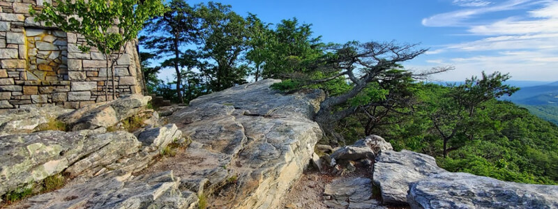
The Hanging Rock Trail begins near the far end of the Visitor’s Center parking lot. Hanging Rock juts 200 feet out of the ground. The overhang was formed as the softer sandstone underlying the durable quartzite top has gradually eroded away. Eventually, the Hanging Rock will come tumbling down as it succumbs to a process of undermining and breaking off.
Cook’s Wall Trail
Length: 2.2 miles one way. Difficulty: Moderate.
The trail begins at the edge of the woods directly behind the bathhouse. At the first fork, turn left onto the Chestnut Oak Nature Trail. Go left at the second fork also. The trail comes to a T intersection at the top of the ridge. To the left, the trail leads to Wolf Rock about 800 feet away and then follows the ridge to the Hanging Rock Trail.
Moore’s Wall Loop Trail
Length: 4.2 miles. Difficulty: Strenuous.
Starts behind the bathhouse just as the Cook’s Wall Trail. At the fork for the Chestnut Oak Nature Trail stay right and follow the edge of the lake. Cross the footbridge and in about 100 yards is the sign marking the start of the loop. Either go right or continue straight, depending upon the direction you want to do the loop. Follow the red blazes to the top of Moore’s Knob (elev. 2572 ft.) and enjoy the panoramic view. The observation tower is a fire tower once used by the N. C. Forest Service.
Chestnut Oak Self-Guided Nature Trail
Length: 3/4ths of a mile. Difficulty: Easy.
Starts at the edge of the woods behind the bathhouse. The trail has 25 numbered stops and a corresponding booklet. The booklets are usually nowhere to be found… A good reason to carry your own field guides. See the booklist above.
Indian Creek Trail
Length: 3.9 miles one way. Difficulty: Easy.
The trail starts at the base of Window Falls and ends at the Dan River. After leaving the Falls, the trail follows Indian Creek, crossing it several times before joining an old roadbed. The trail then takes a sharp right and leaves the roadbed and continues to follow the creek. It crosses Hanging Rock Rd. outside the park gate and roughly follows Indian Creek all the way to the Dan River.
Lower Cascades Trail
Length: 3/10ths of a mile one way. Difficulty: Easy.
Leave the park gate and turn left onto Moore’s Springs Rd. Take the next left onto Hall Rd. to a parking lot on the right. The trail begins at the far end of the parking lot. A short hike takes you to the edge of the gorge where you can watch Cascade Creek tumble 120 feet through a series of falls.
Upper Cascades Trail
Length: 2/10ths of a mile one way. Difficulty: Easy.
The trail starts at the lower-left corner of the Visitor’s Center parking lot. Handicapped accessible, with an observation deck built above the falls.
Length: 6/10ths of a mile one way. Difficulty: Moderate.
The trail starts st the end of the Visitor’s Center parking lot.
Tory’s Den & Tory’s Falls
Length: 4.2 miles one way. Difficulty: Moderate.
The trail starts behind the bathhouse. Follow the Moore’s Wall Loop Trail until you get to an intersection marked by a sign. Follow the trail blazed with blue dots. You can also get there by road. Leave the park and turn left onto Moore’s Springs Rd. Drive 3 to 4 miles and turn left onto SR 2011 (Mickey Rd.) Take the second left onto Charlie Young Rd. and go to the parking lot. Follow the blue dot trail for 1/2 mile to the Falls and Tory’s Den. Tory’s Falls is a multilevel 240-foot cascade.
Summary – Hanging Rock
Location: Stokes County, about 30 miles north of Winston-Salem and four miles northwest of Danbury.
Access: NC highways 89 or 66 to SR 1001, which leads to the park entrance.
Established: In 1936 the Winston-Salem Foundation and the Stokes County Committee for Hanging Rock donated 3096 acres to North Carolina for establishing a state park. Most facilities in the park were constructed by the CCC between 1935 and 1942.
Size: 6457 acres in 2000.
Elevation: 2572 ft. atop Moores Knob.