
Greensboro’s watershed trails are the city’s best-kept secret. I can only think of few other towns the size of Greensboro where you can find a wilderness setting so close to the city. Hike in a mile or so on the Laurel Bluff or Owl’s Roost Trails and you’ll forget there’s a major metropolitan area less than 10 minutes away.
32 Miles of Trail
Contents
This 32-mile network of watershed trails is a blessed side-effect of the city’s otherwise unfortunate geography. Unlike its water-wealthy neighbor to the west – Winston-Salem – Greensboro sits at the top of the Cape Fear River basin, with no large rivers nearby to quench its thirst. In response, the city built a stair-step reservoir system about 10 miles north of downtown that collects water from a 105 square mile watershed and deposits it in Lakes Higgins, Brandt, and Townsend. When originally constructed, the land surrounding these lakes was primarily rural. But by the mid-1980s, development was booming in the watershed as Greensboro’s suburbs marched outward. A save-the-watershed movement sprang up, and in 1988, Guilford County residents approved a bond issue to purchase a 750 ft. buffer of undisturbed land for the three lakes. In so doing, the county’s residents purchased not only watershed protection but a superb recreation facility as well.
Although funded with county money, Greensboro’s Parks and Recreation Department is charged with overseeing the trails. Through a cooperative effort, the city supplies materials, and local civic organizations, such as the Audubon Society, the Sierra Club, and the Greensboro Fat Tire Society provide labor to build and maintain the trails.
NC Mountains to the Sea Trail
These trails are so highly regarded that several of them have been incorporated into North Carolina’s Mountains to the Sea Trail (MST). At 20.6 miles, this portion of the MST (look for the white diamond-shaped blaze) is a bit long for a single-day hike. But road crossings are frequent, so it’s easy to break the hike up into several short sections. Why not hike it over several consecutive weekends this spring? It’s an intimate way to experience the transition from the barren landscape of late winter to the exuberant coming-out of mid-spring. Here’s how:
- Start at Bur-Mil Park and follow the Owl’s Roost Trail along the shore of Lake Brandt.
- At a little over five miles, you’ll intersect with the Lake Brandt Greenway.
- Turn left and cross the Piedmont Land Conservancy’s Weaver Bridge, then take a left onto the Nat Greene Trail and follow it for 3.2 miles until you reach the Lake Brandt Marina.
- Cross the road and catch the Laurel Bluff Trail along the south side of Reedy Fork Creek and the upper end of Lake Townsend.
- When you reach Church St., cross the road and follow the Peninsula Trail a short 1.2 miles until you come back out on Church St.
- Take Church St. across the bridge and dive into the Osprey Trail on your left.
- Follow it to Yanceyville Rd., cross and continue on the Townsend Trail all the way into Bryan Park and the Lake Townsend Marina. (Roadside parking is available at all trailheads.)
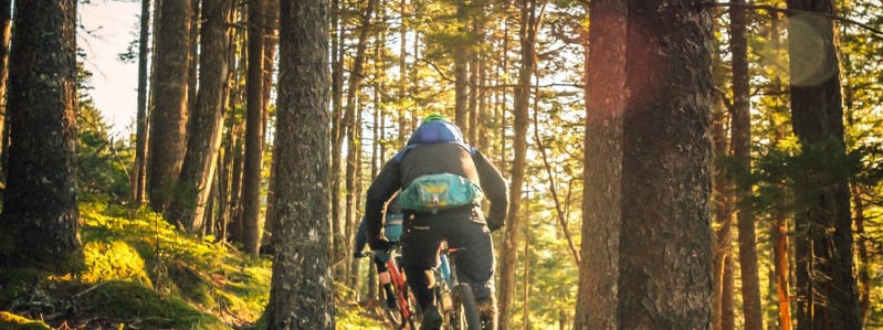
Greensboro Mountain Biking
Greensboro’s watershed trails are also the triad’s premier mountain biking destination. The Greensboro Fat Tire Society has worked closely with the Parks and Recreation Department to develop and maintain more than 15 miles of trails. Almost all of these miles are highly-prized single track, the narrow twisting paths through the woods that are the most challenging and exhilarating for serious mountain bikers. (See below for a list of the trails that are open to mountain bikes.)
Of course, there’s a good chance that once initiated, you’ll find that hiking or biking these trails one time isn’t enough. I find myself going back to the same trails repeatedly, hiking them in every season, time of day, and weather. There’s always a surprise in store. One day a couple of years ago I found a Columbine in bloom smack in the middle of the Laurel Bluff Trail. I’ve been spooked on several occasions by the thunderous liftoff of a flock of Wild Turkeys. Other pleasures are more subtle. I’ve mentally cataloged the gradual disintegration of a red oak brought down by Hurricane Fran in 1996. And every year I watch the earth in a favorite patch of deep woods sprout Mayapple, Dwarf Crested Iris, Foamflower, Orchids, Bloodroot, Green ‘n Golds, and Black Cohosh.
Peninsula Trail
But these trails aren’t just for nature study. They provide a window into human history too. On the Peninsula Trail, you’ll walk over a forest floor covered in leaves and pine needles that hides the wavelike turf beneath, a telltale reminder of this land’s previous incarnation as a farmer’s field. And portions of some trails skirt the edges of suburban backyards, offering a glimpse of our piedmont landscape’s future. No matter what type of outdoor experience you’re looking for, these trails have something to offer.
Lake Higgins Trail
The Lake Higgins Trail, a short loop trail of one-half mile, is an excellent trail for children and is often used by the marina’s staff as an outdoor classroom. For a true wilderness experience, hike from Bur-Mil Park along the Owl’s Roost Trail to the fire lanes that cross the interior of the peninsula. (Look out for mountain bikers; in this remote section of woods you’ll also find some of the best single-track in the triad.)
Laurel Bluff Trail
For solitude, try the Laurel Bluff Trail between Church St. and Lake Brandt Rd. For a spectacular view of wetlands and waterfowl, particularly in fall or spring, try the Beech Bluff Trail between Lewiston Rd. and Brass Eagle Loop.
Reedy Fork Trail
To experience a classic piedmont bottomland hardwood forest, hike or bike the Reedy Fork Trail between Lake Brandt Rd. and Church St.
Bald Eagle Trail
If you want to see Guilford County’s only known Bald Eagle nesting site, hike or bike the aptly named Bald Eagle Trail from the Lake Higgins Marina to Carlson Dairy Rd.
Summary – Greensboro Watershed Trails
Location: Northwest Greensboro, (Guilford County)
Access: US 220/Battleground Ave. to Owls Roost Rd. and Bur-Mil Park. US 220/Battleground Ave. to Hamburg Mill Rd and the Lake Higgins marina. Lake Brandt Rd. to the Lake Brandt Marina. Church St. or Yanceyville Rd. north to several trailheads along the roadside.
Thirty-two miles of trails, including a 20-mile section of the Mountains-to-Sea Trail (MST)
- Lake Higgins Trail – 1/2 mile. Bicycles prohibited.
- Bald Eagle Trail – 3 miles. Bicycles allowed.
- Beech Bluff Trail – 1 mile. Bicycles prohibited.
- Piedmont Trail – 3 miles. Bicycles prohibited.
- Owls Roost Trail – 5.2 miles. Bicycles allowed.
- Nat Greene Trail – 3.2 miles. Bicycles prohibited.
- Laurel Bluff Trail – 3.5 miles. Bicycles Prohibited.
- Reedy Fork Trail – 3.7 miles. Bicycles allowed.
- Peninsula Trail – 1.2 miles. Bicycles prohibited.
- Osprey Trail – 2.4 miles. Bicycles prohibited.
- Townsend Trail – 5.1 miles. Bicycles prohibited.