
The Linville Gorge Wilderness Area is sometimes called the Grand Canyon of the East, but the metaphor doesn’t exactly fit because in the real Grand Canyon you aren’t constantly assaulted by the low hanging branches of rhododendron thickets, or crawling under downed trees, or ducking to avoid an overhanging rock face that won’t allow you to walk upright along a narrow slippery rock shelf that is the only passage along a cliff face that rises 150 feet straight up from the Linville River.
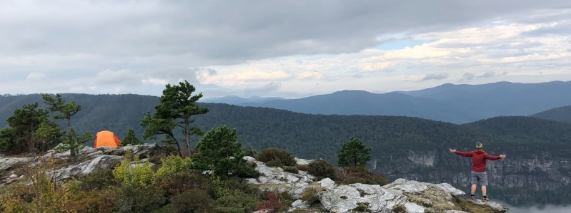
Tucked away in a corner of North Carolina’s Pisgah National Forest, between Lake James and Grandfather Mountain, the Linville Gorge Wilderness Area is so rugged that it was spared the clear-cut logging that was inflicted on most of our eastern forests shortly after the turn of the century. US Army Rangers and US Marines do their wilderness training here. Tenderfoots beware: Linville Gorge is no walk in the park.
And that is why thousands of wilderness pilgrims come every year to pay homage to the Gorge’s remnant virgin forests, spectacular overlooks, and unruly whitewater river, all of which can be taken in on a relatively short day hike.
Named for William Linville, an explorer who lived nearby and was killed by the Cherokees in 1766, the 12,000 acres Linville Gorge Wilderness is one of the original components of the National Wilderness System.
Linville Falls
Contents
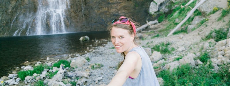
The centerpiece attraction– the Linville River — is also the chief architect of this wilderness sculpture. The river begins as a trickle high on the southwest slope of nearby Grandfather Mountain and enters the Gorge at Linville Falls, an impressive 90-foot multilevel cascade known as a cap-rock fall. Geologists believe that millions of years ago Linville Falls was on the Blue Ridge escarpment, about12 miles south of where it is now. But thanks to a quirk of geology, this area is distinguished by a hard, erosion-resistant layer of rock that overlays younger, softer rocks. These softer rocks erode more quickly, undercutting the hard layer and forming a precipice (the cap) that eventually collapses of its own weight. Through this process of undermining and collapsing, Linville Falls has gradually migrated north, leaving the gorge in its wake.
After leaving the falls, the Linville River drops almost 2000 feet over the next 14 miles as it weaves a serpentine path around the spiny ridges of the adjacent mountains before spilling into Lake James at the entrance to the piedmont. Nearly vertical rock outcroppings several hundred feet high borders the river throughout much of the Gorge. One peninsula, the 400 foot high Babel Tower, stands above the river like the turret on a medieval castle. Blocked from its southward course, the river detours and surrounds the peninsula, nearly forming a moat.
No wonder the Cherokees called the river “Eeseeoh,” “a river of many cliffs.” Today, these cliffs attract scores of rock climbers. Shortoff Mountain and Table Rock, on the east rim of the Gorge, are two of North Carolina’s premier climbing destinations.
Linville Gorge
Linville Gorge features some of the best remnant stands of uncut forest in the southern Appalachians. If you overturn a few rocks in the damp coves of virgin hemlock and yellow poplar there’s a good chance you’ll see a salamander scurry for cover. But it’s a different world on the dry ridgetops nearby. There, you’ll find a fire-dependent ecosystem that is home to endangered plants such as Heller’s Blazing Star and Mountain Golden Heather, a species that lives nowhere else except nearby Grandfather Mountain. With such vastly different ecosystems in close proximity, it’s no surprise that Linville Gorge hosts at least five species of rare plants.
But it’s the gushing profusion of plant life that makes Linville Gorge such a treat for hikers. In early spring look for Large Flowered Trillium and Toad Trillium blooming alongside the Linville Gorge Trail. In summer look for the white spires of Galax along the Bynum Bluff Trail and other ridgetop trails.
And don’t forget to look up. Once, while hiking near the Chimneys on the east rim of the Gorge, a friend spotted a large crow-sized bird plummeting missile-like into the depths of the Gorge. It was a Peregrine Falcon, one of many that now call Linville Gorge home.
Linville Gorge Trail
Trails on both rims of the distinctly V-shaped gorge lead down to the river, and the descent is always steep. Cabin Trail, on the west rim, drops almost 1000 feet in 3/4 of a mile. The Linville Gorge Trail is the major connecting trail. It parallels the river on its west side for about 12 miles. Seven trails descend from the rutted access road SR-1238 (the Kistler Memorial Highway) to the Linville Gorge Trail. On the east rim, three trails lead from Forest Road 210 to the river, and only one of these, Spence Ridge, – receives regular use and is likely to be clear of downed trees. Trails also lead from Forest Road 210 to Table Rock and Hawksbill Mountains, two of the most distinctive peaks in the southern Appalachians.
Hikers should remember that this is a federally designated Wilderness Area. As we learned on our end-to-end trek of the Gorge, trails are not well maintained and are marked only at the trailheads at the top. Even veteran hikers will find that it is very easy to lose the trail. It’s no surprise that 45 to 50 hikers per year get lost or injured and have to be rescued by local emergency crews.
Linville Gorge can be very crowded on weekends during the summer months. The busiest trails are Babel Tower on the west side and Spence Ridge on the east. If possible, plan to go on a weekday during summer, or better yet, visit between late fall and early spring, before the bugs come out and the copperheads and rattlesnakes are not very active.
Summary – Linville Gorge
- Location: Pisgah National Forest, Burke County. Lake James and Morganton lie to the south and the main crest of the Blue Ridge lies to the north.
- Access: US 221, NC HWYs 181 and 183, and the Blue Ridge Parkway at milepost 314.
- Elevation: 1300 ft. to 4040 ft.
- Size: 12,000 acres.
- Established: 1964. An original component of the National Wilderness System.
Getting there: West Rim of the Gorge
Take I-40 to Exit 105 — Sterling Street/N.C. 18 in Morganton, and head north through the center of the city. After about 1 1/2 miles, the road becomes N.C. 181. Continue north on 181 about 25 miles to the intersection with NC 183 at the bottom of a long hill. Turn left onto 183 and go several miles until you see the sign for the Linville Gorge Wilderness and Linville Falls on your left. Turn left onto SR 1238 (Kistler Memorial Highway). Be aware that SR 1238 is extremely rutted. 4-wheel drive is recommended south of the Babel Tower Trailhead.
Camping Permits
A permit is required to camp overnight on Friday, Saturday, Sunday, and holidays between May 1st and October 31st. No more than 10 people per group. The maximum length of stay is 3 days and 2 nights. Call the Grandfather District Ranger at 828-652-4841 or 2144 to secure a permit.